White Butte Trails Info
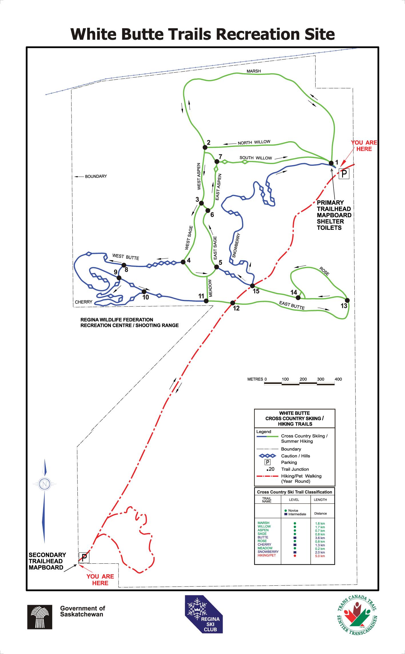
The White Butte Recreation Site, 20 minutes east of Regina, features 13 kilometers of regularly groomed ski trails through gently rolling, treed terrain. Amenities include two parking lots, two warm-up shelters and an outdoor toilet.
There are also 5 kilometers of specially designated trails for pets & walkers. Neither walkers nor pets are allowed on the winter ski trails due to the risk of injury to all, and to maintain trail quality. A sheltered winter walking/dog trail and snowshoe area is accessed from the secondary (south west) parking lot. Fat bikes are restricted to walking/dog trails & snowshoe area.
Watch for signage at both primary & secondary trail heads which indicate the location of the different trails designed especially for skiing, snowshoeing, fat-biking, hiking or pet-walking. Within the skiing area, signs at every trail junction make it clear where you are and how to return to the Primary Trailhead.
The Regina Ski Club (RSC), through a formal agreement with Saskatchewan Parks(SPCS), manages this facility during the winter.
The objective is to provide high quality cross-country ski trails for recreational and competitive skiers for both classic and skating techniques. The skating lane (full trail width initially) is machine packed first to establish a base. The classic track (two parallel groves) is machine ‘set’ to one side as soon as there is sufficient snow to cover all ground litter. The Marsh trail is a designated classic area (no skating) to be skied-in manually until there is enough snow to use machinery.
Frequent trail grooming is required for optimal skiing conditions making it necessary, in the absence of trail fees, to appeal for donations. Options include deposits in the trailhead cash boxes, by e-transfer or by snail mail. For details see our Donations page.
How to get to White Butte Trails
White Butte Trails has two entrance points. The Primary Trailhead, designed primarily for skiers, is at the northeast corner of the property. The Secondary Trailhead is at the southwest corner, just south of the Regina Wildlife Federation & biathlon area. Adjacent to this parking lot is a sheltered trail dedicated to hiking and pet-walking.
Directions to White Butte Trails Primary Trailhead (North East)
The White Butte Trails Primary Trailhead is about 3 kilometres straight north of Emerald Park / White City to the east of Pilot Butte. Directions:
From north Regina: Head east on Highway 46, which is accessible from north Winnipeg, McDonald or Fleet Streets. Drive 13.1 km east of Fleet St to the Frankslake Road, where there is a Cross-Country Skier sign. Turn right and drive south 1.6km, crossing the CPR main line tracks. The White Butte Trails Primary Trailhead is on your right, but you will see only the back of the large trail sign.
From south Regina: Head east on #1 Trans-Canada Highway 13.1 km from Fleet Street, taking the Hwy #48 exit at White City. At the intersection of the off-ramp and Hwy #48 (which is divided at that point), turn left (north) crossing Hwy #1 via the overpass to a T-junction at the north service road. Turn left again and travel back west for 600 metres to the Frankslake Road. Turn right and drive north for 3.2 km until you see the White Butte Trails sign on your left. Watch for the Cross-Country Skier signs to direct you at each turn.

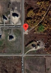
Directions to White Butte Trails Secondary Trailhead (southwest entrance)
The White Butte Trails Secondary Trailhead is about 3 kilometres east of the Pilot Butte turn-off at Sask Highway 362 and about a kilometre north of the Trans-Canada Highway.
Directions:
Head east on #1 Trans-Canada Highway from Fleet Street for about 8 km, taking the Pilot Butte exit. At the intersection of the off-ramp and Hwy #362 to Pilot Butte, turn left to cross Hwy #1. In 600 meters is the first intersection north of the overpass, the north service road. Turn right to follow the north service road east 3.6 km to Range Road 2182. The most visible sign at this intersection says “Stone Point Acres”. Turn left (north) about 900 metres. On your left is the beginning of Stone Point Acres residential subdivision. To the right is a small parking lot at the Secondary Trailhead of White Butte Trails.

The Story of White Butte
White Butte was established in 1982. Its name is an amalgamation of the names of two adjacent communities, White City and Pilot Butte. Following lobbying efforts by members of the Regina Ski Club, the Saskatchewan Natural History Society, and numerous other interested persons, the provincial government offered the area, now known as White Butte, for use as a cross-country ski area, recreation area, and wildlife refuge.
The site offered skiers some thick bush for wind protection, rolling topography, and a number of old vehicle trails that could be included in ski trail planning. In 1983, Bob Herbison, park planner for the provincial government, used maps and aerial photos to pre-plan the proposed ski trails. A group of volunteers worked with him, flagging the bush prior to trail cutting by the government. By removing stones, stumps, and old car bodies, and filling in some wet spots. Ski club volunteers have improved these trails yearly, and added first the Cherry trails, followed by Snowberry.
A number of years ago, we were in danger of losing White Butte when the Saskatchewan Department of Highways proposed routing Highway 46 to Balgonie through the area. Fortunately, lobbying by the Regina Ski Club, Saskatchewan Natural History Society, and others prevailed and the area was saved for our enjoyment.
The warming hut at the trailhead was supplied by the provincial government and moved, at Regina Ski Club’s expense, from Valeport to White Butte. Bob Herbison, Susan McGillivray, Ron Blechinger, Hal Herbison, Bob Serban, Joe Turnham, Gregg Brewster, and Gene Josephson are just a few of the many club members who deserve honorable mention as White Butte builders.
In 2006, the entire White Butte trail system was designated a part of the Trans-Canada Trail. White Butte is classified as a recreation site and is part of the Saskatchewan provincial park system. It is presently under the jurisdiction of the Ministry of Tourism, Parks, Culture and Sport.
~Peter Whitehead
